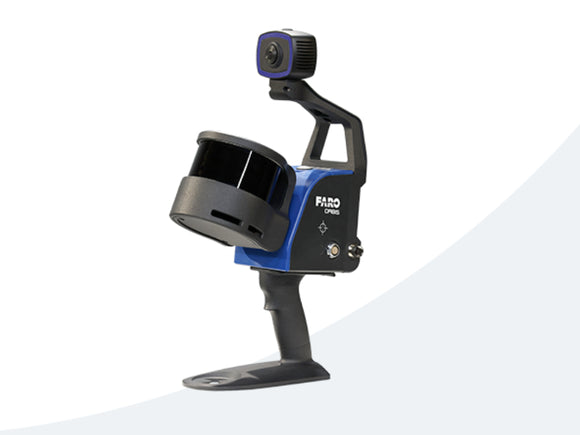


Faro Orbis Mobile Laser Scanner
For availability please enquire on 020 8640 2960. These are not stock items and are shipped to order.
Faro Orbis Mobile Laser Scanner
FARO® Orbis™ is a revolutionary mobile scanning solution built to maximize productivity and optimize workflow. Engineered for construction, engineering and surveying professionals, Orbis scans the real world rapidly and with extreme accuracy, producing 3D visualizations.
Featuring FARO’s Flash Technology™, Orbis performs stationary scans in just 15 seconds, offering unmatched detail from a mobile mapping system. GeoSLAM's leading-edge SLAM algorithm powers Orbis to deliver accurate results faster, reducing potential for human error and elevating efficiency. Combining mobile scanning with stationary Flash scanning, Orbis is the perfect partner to conquer the modern scanning landscape.
Hybrid Reality Capture with FLASH Technology
Improve your mobile scanning quality with Hybrid Reality Capture powered by FARO’s proprietary Flash Technology. Previously unseen in a mobile scanning solution, Orbis offers mobile scanning and stationary scanning capabilities with Flash, delivering high quality, accurate, and dense datasets. It’s a combination of speed, data clarity and accuracy in one complete scanning solution.
Advatages:
Hybrid Reality Capture with FLASH TechnologyImprove your mobile scanning quality with Hybrid Reality Capture powered by FARO’s proprietary Flash Technology. Previously unseen in a mobile scanning solution, Orbis offers mobile scanning and stationary scanning capabilities with Flash, delivering high quality, accurate, and dense datasets. It’s a combination of speed, data clarity and accuracy in one complete scanning solution. |
10x Faster Than Other Surveying MethodsExperience unmatched speed of data capture with mobile scanning technology. Designed for rapid deployment, Orbis ensures fast and accurate data acquisition, revolutionizing your project timelines. It empowers users to capture detailed and accurate spatial data 10x faster than traditional laser scanning, accelerating workflows and ensuring you stay ahead in today’s fast-paced world. |
Frequent Data Capture for Better InsightsCapture 3D data more frequently and comprehensively than ever before and elevate your data insights. Stay up to date with fast-paced and evolving scenarios like construction progress, enhancing decision-making and improving collaboration. Ease of use and portability make frequent data capture possible, without impacting jobsite production – a constant stream of fresh insights to transform your projects and deliverables. |
Scanning Doesn’t Need to be ComplicatedDesigned with usability in mind, scanning with Orbis is as simple as pushing a button and walking with the device. It simplifies complex surveying tasks, enabling efficient data collection for a broader audience, across various industries. Expanding the opportunities for data capture in previously unobtainable places. |
The World’s Leading SLAM AlgorithmGeoSLAM’s proprietary SLAM algorithm drives Orbis and has been tried and tested in some of the most difficult environments, for over a decade. Constant innovation from customer input has led to the SLAM algorithm that continues to deliver and improve customer projects, in a myriad of industries. |
One Year WarrantyWe design, build and test our products with quality as a top priority. Because we believe in our hardware, Orbis comes with a one-year warranty as standard. We also offer affordable extended service plans, so you can have peace of mind and prevent unexpected expenses. |
Features:
Lightweight and Easy-to-UseWeighing just 3.6kg, including the datalogger and battery, Orbis is ideal for scanning large areas fast, without large setups. |
Higher Levels of AccuracyA precision of 5mm during a mobile scan and 2mm during stationary Flash scanning makes Orbis the ultimate mobile scanning solution for high levels of accuracy. |
Ideal for Internal and External MappingWith up to 120 meters in range, Orbis is the ideal solution for both indoor and outdoor scanning, with the ability to seamlessly transition between both. |
Best of Both Worlds ProcessingOrbis offers local processing in the FARO Connect software or optional FARO Sphere® XG Digital Reality platform – flexible solutions for processing, analyzing and sharing data. |
360° Photos and Colorized DataThe integrated 8-megapixel camera on the Orbis enables colorized point clouds and additional 360° panoramic pictures. |
Engineered for the Toughest EnvironmentsEngineered with the toughest environments in mind, Orbis has the capacity to map places like underground mines, dense forests or construction sites with ease. |
The All-in-one Mapping SolutionThe Orbis is compatible with a monopod for stationary Flash scanning, car mount for capturing larger areas, backpack for tough terrain, and cradle for descending into a mine shaft, it is truly an all-in-one solution. |
Applications:
AEC |
Mining |
Geospatial |
The Perfect Tool for Repeatable Data Capture and CollaborationTo ensure your construction projects remain on track, it’s essential to review changes over time. Orbis offers a fast and accurate method of data capture, making it possible to analyze progress on a monthly, weekly or even daily basis without causing disruption to job-site activities. |
Rapid Site Information for the Modern MineOrbis is an ideal tool for capturing both overground and underground data, thanks to its impressive rate of data capture and range capabilities. You can utilize it to capture stockpile volumetric calculations, production progress mapping, convergence analysis or vertical shaft inspection. By doing so, you effectively reduce risk to human life by limiting exposure to hazardous environments and optimize mining operations to yield better returns on investment. |
A Faster Way to Capture your DataOrbis offers a versatile scanning workflow, combining fast mobile scanning data acquisition with detailed static scans using Flash Technology. It excels in various applications, including geospatial workflows making it the ideal choice for tasks that demand flexibility and precision. Whether you need fast data capture in dynamic scanning or meticulous Flash scans, Orbis delivers outstanding results, accommodating a wide range of job requirements. |