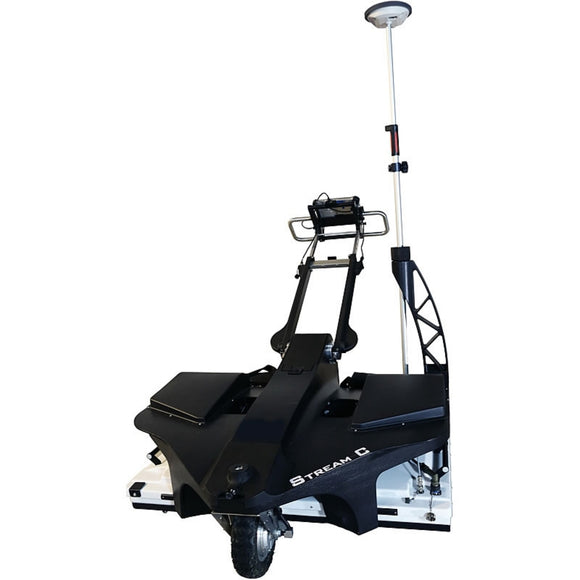
IDS GeoRadar Stream C GPR
Surveying companies require compact solutions that increase productivity and workflow efficiency. Stream C Ground Penetrating Radar (GPR) detects underground utilities in real time and quickly produces subsurface GIS-based digital maps. Due to the system’s flexibility and size, Stream C can be used in urban environments and for a wide range of applications, from pipe mapping, civil engineering, archaeology to tunnel and bridge detection.
The system set up is simple – just bring it on site, unload, plug in the GPS and you’re ready to work.
The vertically and horizontally polarised antennas deliver high-quality results while scanning in just one direction. The user-friendly GPR allows real-time monitoring also for non-experienced GPR users
Stream C is the compact array solution for real-time 3D mapping of underground utilities and features. Thanks to the increased level of accuracy, provided by a massive antenna array, Stream C is able to detect pipes and cables automatically.
Daily use of Stream C is aided by ergonomic features including electronic ride height adjustment, options to tow manually or with a small vehicle, and a motor assisted drive wheel.
Stream C is available in both Basic and Advanced configurations.
The system features:
- Massive array of 34 antennas in two polarisations: An accurate 3D reconstruction of the underground utility network is created in a single scan.
- Automatic Pipe Detection (APD): Real-time automatic detection of buried pipes and cables.
- Compact size: Stream C’s small dimensions enable it to survey areas inaccessible to larger array systems while maintaining the same accuracy.
- Robust construction: Built to the highest standards and with robust materials so that it can be used in harsh, demanding environments.
- 3D radar tomography: Real-time tomography on a GPS or total station assisted cartographic background.
- Professional subsurface survey: Quickly produce subsurface GIS based digital maps when pipes, cables and buried objects are automatically transferred to CAD and GIS formats.
Benefits of the Stream C include:
- High Productivity: Surveys only need to be performed in one direction to ensure optimal detection of both longitudinal and transversal pipes;
- No advanced training needed: The system automatically detects and locates the position of pipes in real time and displays them on screen;
- Reduced user fatigue: Thanks to electronic ride height adjustment and a motor assisted drive wheel;
- Facilitates large surveys: The system can be towed manually or with a small vehicle, increasing the acquisition speed (up to 6 km/h).